Crime & Safety
NMPD Asks Borough Residents to Prepare for Hurricane
Chief Frank Papapietro urges residents to use extreme caution

Borough officials posted a message to residents on New Milford's website Thursday afternoon, urging residents to be prepared for the arrival of Hurricane Irene this weekend.
"Hurricane Irene is expected to impact the NY/NJ area this weekend," said NMPD Chief Frank Papapietro in his message. "While the exact path of the storm is still uncertain, all residents should prepare at the very least for a significant rain event from Sunday into Monday."
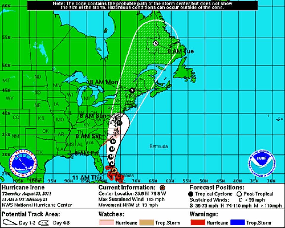
Papapietro said Irene is currently a Category 3 storm and that its current path over water could intensify the storm as it approaches Bergen County.
Find out what's happening in New Milfordwith free, real-time updates from Patch.
The NMPD issued a list of specific precautions borough residents could take in advance of this weekend:
- Have flashlights/battery operated radios and fresh batteries on hand and be sure that generators are operable.
- Secure outdoor furniture and trash/recycling containers.
- Do not call the police to ask when the storm will end. Monitor local weather and news channels. Call 9-1-1 for emergencies only.
- Do not venture out unless it is an emergency.
- Do not drive through flooded areas. Water is often deeper than it appears and motorists whose vehicles become disabled tie up rescue crews. Also, do not drive around barricades unless directed by officials to do so.
- Be sure your prescription medication does not need to be refilled.
- Check on elderly neighbors.
Borough officials had guidance for residents who live in flood prone areas of New Milford:
Find out what's happening in New Milfordwith free, real-time updates from Patch.
- Move valuables and important papers to higher elevations in the home
- In the event of an evacuation prepare a go-bag containing medication, two days change of clothing and important papers.
- Prepare a go-bag for your pets
- Have a plan for temporary lodging with family or friends although shelters are being set up.
- Move vehicles to higher elevation.
The National Weather Service has issued a Hazardous Weather Outlook for this weekend. Here is a complete forecast through the beginning of next week from the NWS:
Thursday afternoon: A chance of showers and thunderstorms. Some of the storms could produce heavy rain. Mostly cloudy, with a high near 86. South wind around 14 mph. Chance of precipitation is 50%. New rainfall amounts between a quarter and half of an inch possible.
Thursday night: Showers and thunderstorms likely, mainly before 11pm. Some of the storms could produce heavy rain. Mostly cloudy, with a low around 69. West wind between 5 and 8 mph. Chance of precipitation is 70%. New rainfall amounts between a quarter and half of an inch possible.
Friday: Mostly sunny, with a high near 86. North wind at 5 mph becoming east.
Friday Night: A slight chance of showers and thunderstorms after 1am. Mostly cloudy, with a low around 68. Light and variable wind. Chance of precipitation is 20%.
Saturday: A chance of showers and thunderstorms. Mostly cloudy, with a high near 84. Calm wind becoming south between 4 and 7 mph. Chance of precipitation is 40%.
Saturday Night: Showers. The rain could be heavy at times. Low around 67. Windy. Chance of precipitation is 80%. New rainfall amounts between a quarter and half of an inch possible.
Sunday: Tropical storm conditions possible. Showers. The rain could be heavy at times. High near 76. Chance of precipitation is 90%.
Sunday Night: Tropical storm conditions possible. Showers likely. Mostly cloudy, with a low around 61. Chance of precipitation is 60%.
Monday: Mostly sunny, with a high near 83.
Get more local news delivered straight to your inbox. Sign up for free Patch newsletters and alerts.


